The work in which this paper is based is hosted by the Laboratory of Urban Analysis and Digital Representation, and brings together two research lines of the Graduate Program in Urban Planning (PROURB / FAU/UFRJ): History of the City and Urbanism and Digital Graphics.
The historical object studied is the work of the French architect Joseph Gire (1876- 1933) in the city of Rio de Janeiro. Graduated from the Ecole Nationale des Beaux Arts in the first decade of the twentieth century, he designed a series of bourgeois houses in Paris, the hôtels particuliers. In 1910, Gire begins an international career designing many upper class buildings of considerable size. In Brazil, he designed many (although yet to be accurately quantified) projects in São Paulo and Rio de Janeiro. However, his work remains unknown in most countries, including France.
The research methodology is drawn from History of Culture, and seeks to map and understand the dialogues maintained by this architect in the city of Rio de Janeiro, contributing to the development of a strategy of analysis and presentation of the works in question. We depart from the notion of cultural exchange, the circulation of ideas and transculturation as a transitive process from one culture to another, therefore avoiding the notion of a one-way conversation with European ideas dominating local production. The analysis is not restricted to the classification of works by architectural styles, but has the objective to examine the transformations in the built environment, urban morphology and social processes either catalyzed or incorporated by these buildings, therefore characterized as “urban icons” at some degree.
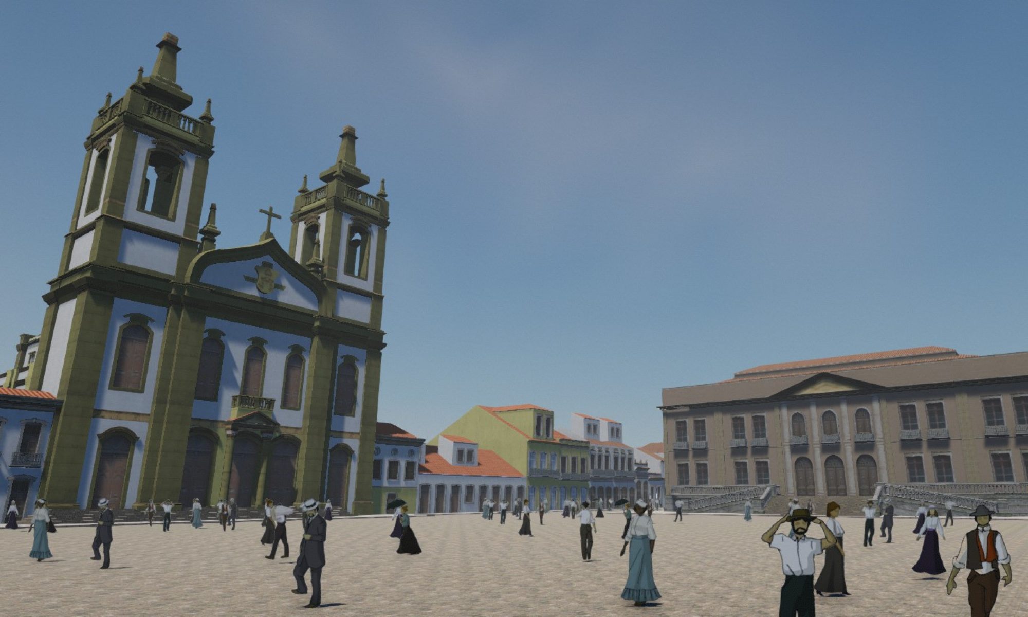
Two of these urban icons are studied in depth, in order to help develop an online application that depicts the architecture works of Gire in Rio: the Copacabana Palace Hotel (1923) and a residential building at Flamengo Beach (1923). For the construction of the digital database, we studied interaction models seeking more subjective and flexible ways to classify, organize and relate data from different source documents as well as different architectural objects records. We also created a navigation prototype to demonstrate and compare tectonic aspects of the buildings, such as structure, materials and construction methods. It also allows the depiction of the buildings’ urban environments as well as their morphological, typological and social contexts, along with their uses and spatiality thus helping envision not only various aspects of the buildings, but also their relationships with the city and with different trends of architectural and urban thought.
Abstract
Contemporary cities scanned by GPS machines are continually redefined by collaborative comments. New kinds of games such as location-based games, urban hunting games and even alternate reality games show a different way of using and understanding the city. This article analyses these different interactive narratives of games that use the city as a platform for devices and applications sensitive to geographic location. The objective is to identify some of these practices that are appropriate to create applications for the dissemination of information about architecture and heritage, using buildings, events and places to enhance the knowledge about the city.
Keywords:
realidade aumentada; jogos baseados em locação; patrimônio virtual
Resumo
Este trabalho tem por objetivo expor reflexões acerca da utilização da computação gráfica no ambiente da pesquisa acadêmica. Tais reflexões e suas consequentes metodologias de aplicação desenvolveram-se a partir de experiências com a modelagem tridimensional relacionadas aos trabalhos realizados no grupo LAURD – Laboratório de Análise Urbana e Representação Digital – que se dedica à utilização das potencialidades desta ferramenta para explorar inéditas possibilidades de representar leituras sobre ícones arquitetônicos e sua inserção no ambiente urbano. Ao longo deste processo, pôde-se desenvolver determinados conceitos metodológicos que direcionaram a elaboração do modelo tridimensional que representa o principal objeto de estudo do grupo LAURD – o edifício do Ministério da Educação e Saúde, também conhecido como Palácio Gustavo Capanema. Neste artigo serão abordadas as metodologias desenvolvidas a partir destes conceitos, assim como serão expostos os resultados obtidos com o modelo elaborado com estas diretrizes.
Abstract
This paper has the objective to expose ideas about the signification of computer graphics in an academic research environment. Those ideas and their consequent work methodologies were developed from experiences with 3d modeling related to the work produced within the research group LAURD, meaning Digital Representation and Urban Analysis Laboratory, which dedicates itself to research the potentialities of those tools in order to explore new possibilities of analysis and studies representations about architectural icons and their insertion in the urban environment. Along this process, could be developed some methodological concepts which conducted the elaboration of 3d models of LAURD’s main study case – the Health and Education Ministry building, also known as Gustavo Capanema Palace. In this paper will be explained the methodologies developed from those concepts, and the consequent results of the 3d model made with them.
Abstract
In this work are presented the initials results in digital analysis of the first urban propose by Affonso Eduardo Reidy in city of Rio de Janeiro – the urbanization of Castelo Esplanade, developed from the use of city’s digital models that represents the central area in many moments of its history. It’s possible to establish new readings about this project and its theorical influences from the conjuction of this results with others digital tools, showing its possibilities in history of architecture and urbanism studies.
Keywords
Digital modeling, Cities, Reidy, Modernism, Rio de Janeiro.
Abstract.
The reassessment of the concept of space under the light of related notions of territory and place, that is, space to which meaning has been added by individuals or institutions, shows that user engagement in virtual heritage applications could be improved by the representation of these symbolic aspects of space. Keywords. Virtual heritage; place; games; hyperdocuments.
Abstract
The construction of urban heritage narratives in hyperdocuments This paper studies mechanisms involved in various kinds of interaction in urban heritage cybertexts – grouped in navigational spaces, including computer games, databases and hyperdocuments – in order to reflect on how they can be improved both from the point of view of interaction. Therefore it also helps to contribute to the development of a laguage able to describe more accurately the works within the field of urban heritage digital representation. Also the production of such works is examined for improvement, especially the activity of writing the script, considering that this author is seldom involved in the programming and modeling.
The panoramas multi-layer: a iconographic hyper document of the history within city of Rio de Janeiro
Abstract
This article intends to investigate the use of a Panorama multi-layer as a hyper document to broaden the understanding the history of the cities. We asume that a Panorama multi-layer, in this opportunity, can convey unusual interpretations with the add of important drawings and pictures made by the travelers wich arrived in Rio de Janjeiro in the beginning of 19th century. This paper aims to demonstrate new possibilities which can be added into the digital and interactive panoramas, and a new way to develop a iconographic hyper document in the central area within the city of Rio de Janeiro.
Keywords
Panoramas; Digital panoramas; interactive; multimedia; history of the city.
Abstract
This paper exposes site “Cidade Interativa” development process, based on: a reflection about importance of users’ points of view’s incorporation for space remodelling; a study about theoretical and practical experiences which, in different ways, approached potencialities of participation of a community’s members in a project; and, finally, a investigation of propagation alternatives of individual readings as information source for urban project, trying to enhance points of view that generally remain occult in the form of invisible practices of anonymous users. This site must be understood as concretion of an idea: creating a vehicle from which is possible to become individual readings public, so that these are shared and, also, make them available to people responsible for urban projects as information source.
Resumo
Este multimidia sobre a evolução da cidade de Buenos Aires, se propõe obter uma primeira aproximação, tanto da sua história como das particularidades que definem alguns lugares significativos que identificam a fisionomia dos espaços urbanos, relacionando sempre os contextos particulares com a sua inserção na escala global da cidade. A navegação que é disponível para a seleção do usuário se articula em quatro temas básicos: a) narração; b) trama; c) documentos; d) cartões postais. Na narração, uma locução se desenvolve acompanhada por imagens de planos, gravuras e fotografias. Na trama, um sistema de ícones permite a leitura interativa das transformações acontecidas nos diferentes componentes urbanos básicos: população , superfície urbana, áreas verdes, sistema viário e o transporte público. Os documentos contêm planos, dados estatísticos e bibliografia.
Abstract
This multimedia refer about the Buenos Aires general historical evolution. Navigation define four basic subjects. a) A narrative description that permits to approximate to its main historical periods, defined by economical and social events. b) The urban grid. Here the user access to the city plan where is possible to have information about the growth of Buenos Aires along the time; the circulation system; density of population; green areas and public transportation. With a particular icon is possible to know about a group of main sites, that have a symbolic meaning in the city. The urban context and the surroundings buildings are analyzed in a detailed way. c) Documents, historical plans, director plans and bibliography. d) postcards that with one hundred pictures of the city is establish a relationship with literature, music, historical films and poetry.
Abstract
Beyond the static image: the digital graphic representation of spatial experience in architecture This work presents some theoretical reflections about the potentialities of digital tools in the graphic representation of architectonical space. Considering de sub-utilization of these tools in mimetic applications of manual graphic methods, it’ll be taken in Theory of Architecture the argumentations needed to justify the importance of 3D videogames technologies in the architectural graphic representation field. Inserting these reflections in the though line of Bruno Zevi, whom already alerted for the limitations of graphic representation in translating the architectonical space nature, it’s perceived that those technologies are capable to overcome them, offering the biggest qualitative gain in the field since the discover of perspective laws in the Renascence. So, it’ll be presented some digital models of projects used as didactic tools, that are capable to give a deeper understanding of built space from the graphic representation of the spatial experience virtually lived there, by allowing the user’s free movement.